Local Running Routes
Local Running Routes
One of the most common questions we get asked at Jus’ Running is, “Where should I run?!” And lucky for you, there is no shortage of routes to run around here. Asheville, North Carolina is a piece of running paradise tucked in the Swannanoa and French Broad River valleys of the Blue Ridge Mountains. Whether you’re wanting road miles or singletrack, you won’t have to look too hard to find a route. Here are some of our local favorites.
November Route of the Month:
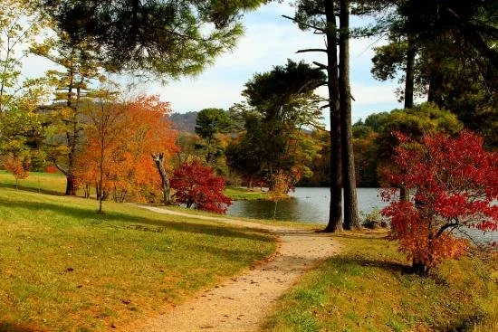
The Asheville Turkey Trot Route
-
Route by Jus’ Running and photo by Curve Theory.
This renowned Asheville race starts at the island on Woodfin St in front of the YMCA (30 Woodfin St Asheville, NC 28801) and will take you through the historic neighborhood of Montford before ending at Pack Square Park (80 Court Plaza, Asheville, NC 28801). No pets or dogs allowed on the course, please, due to the congestion in and around the start/finish line. The course is not completely closed so this is for safety purposes. Strollers are welcome, and will be asked to start at the back of the pack. Faster folks in front, walkers in back.
Turn-by-turn course description:
-Race starts on Woodfin Street in front of the downtown YMCA
-Head toward Central Ave, turn right.
-To the top of the hill, turn right on E. Chestnut St.
-Turn left on Charlotte
-Follow Charlotte St to Evelyn Place, turn left
-Follow Evelyn place, crossing Edwin/Kimberly to Murdock St, turn left onto Murdock
-Follow Murdock to Hillside St, tun right
-Hillside to N. Liberty, turn left.
-Follow Liberty, crossing Chestnut St to Orange St, turn left
-Follow Orange to Central Ave., turn right onto Central
-Follow Central Ave down to Woodfin St, turn left on Woodfin
-Follow Woodfin which changes name to Oak St. to the traffic circle
-Turn right onto College St.
-Finish is approximately .1 mile on the left at City/County Plaza
-
3.1 miles
-
Road
-
Downtown street parking
-
See map here

Biltmore Forest Figure-8
-
Route and photo by staff member Miranda Redmann (with her dog Franny) in Biltmore Forest
Starting at the Rosebank Park (Park Rd) in Biltmore Forest, turn right out of the small parking lot towards Vanderbilt Rd.
Turn left on Vanderbilt Rd, continuing to the intersection of Vanderbilt and Busbee Rd.
Turn left on Busbee Rd. Continue on Busbee until it meets the edge of Biltmore Estate property and Cedarcliff Rd.
Turn right on Cedarcliff Rd. Continue on Cedarcliff until it meets Forest Rd.
Turn right on Forest Rd. Continue on Forest Rd. Forest will eventually intersect with Busbee Rd., continue straight on Forest through the intersection. Stay on Forest Rd until it meets with E Forest Rd.
Take a slight left onto E Forest Rd. Continue on E Forest Rd until it meets with Vanderbilt Rd.
Turn left on Vanderbilt Rd. Continue on Vanderbilt Rd. Stay left on Vanderbilt Rd where it meets with Arboretum Rd and then Southwood Rd. Stay on Vanderbilt Rd until it loops back to Rosebank Park.
From Vanderbilt Rd, take a left of Park Rd to return to the parking lot at Rosebank Park.
-
4.14 miles
-
Road
-
Rosebank Park (Park Rd) in Biltmore Forest
-
See map here

Charlotte-Chestnut-Montford Loop
-
Contributed by staff member Miranda Redmann
Starting at Jus’ Running, leave the parking lot going left on Merrimon Ave. Take the first left onto Murdock Ave. Take Murdock all the way to the end and turn left on Hillside St. Take a right onto Charlotte St and continue on Charlotte until the intersection with E Chestnut St. Take a right onto Chestnut. Take Chestnut all the way down, crossing Merrimon, then crossing Broadway Ave. Continue onto W Chestnut St into Montford. Continuing on W Chestnut, cross Montford Ave and turn right onto Pearson Dr. Stay on Pearson for about three-quarters of a mile then turn right onto Santee St. Santee meets up with Montford Ave. I recommend crossing Montford Ave and turning right to stay on the sidewalk. From Montford Ave, take a left on Panola St; stay left on Panola until it hairpins right, then take the left onto Catawba St. From Catawba, take a left onto the Reed Creek Greenway. Take the greenway all the way to the intersection of Broadway Ave and WT Weaver Blvd. Use the traffic light button to cross Broadway onto WT Weaver Blvd. Continue onto the Glenn Creek Greenway, which parallels WT Weaver Blvd. At the end of the greenway, carefully cross Merrimon Ave and turn left on Merrimon to return to Jus’ Running.
photo by Savanna Waites
-
4.8 miles
-
Road
-
Jus’ Running 523 Merrimon Ave
-

-
Starting at Jus’ Running (or Weaver Park on Murdock Ave) turn left on Merrimon Ave then left on Murdock Ave. Continue on Murdock Ave then turn left on Evelyn Place and left on Kimberly Ave. Take Kimberly Ave all the way past the golf course and turn right on Griffing Blvd. Run up Griffing around the Rose Garden (this should be a little lollipop loop, going up one side and coming down the other) and back down to Kimberly Ave. Turn right on Kimberly Ave, then left on Hampstead Road then right on Holborne Street. Turn left back onto Kimberly Ave. Take Kimberly all the way down hill until it meets with Beaverdam Rd. Turn left on Beaverdam then right on Dover Street. Take Dover down to Merrimon Ave. Cross Merrimon -VERY CAREFULLY- and stay left on Merrimon until you reach Beaver Lake. Take a slight left onto the gravel path that goes around Beaver Lake. This month, we’re doing the smaller, figure-8 loop around Beaver Lake so you’ll get back onto Merrimon Ave where you entered the Beaver Lake path. Leaving the path, turn right onto Merrimon. Continue on Merrimon until the intersection of Merrimon and Ottari. Use the crosswalk to cross Merrimon and continue up Ottari Road. Run uphill then turn right on Manetta Road. Take Manetta all the way down and turn left on Gracelyn Rd. Gracelyn will meet back up with Kimberly and you’ll turn right on Kimberly. Run downhill to Edgewood Rd and turn right then take a quick left off of Edgewood to Service Entrance. Take Service Entrance to Norwood Ave. This is Norwood Park, a neighborhood behind Jus’ Running. Turn right on Woodward Ave and take Woodward all the way down getting you back down to Murdock Ave. Turn right on Murdock, right on Merrimon, then right back into the Jus’ Running parking lot.
-
5.51 miles
-
Road
-
Jus’ Running
-
https://onthegomap.com/s/ggsto750
NAVL Tour
West Asheville Brewery Hop
-
Connect two distinct parts of Asheville (with multiple options to grab a beer!) with this route. Park at the Craven Street Public Parking area off Emma Rd and Hazel Mill, and jump onto the French Broad Greenway for about half a mile, passing New Belgium on your right and the French Broad River on your left. As soon as you pass under the bridge, hop onto Haywood Road heading south. You’ll hit Archetype Brewing next (after a little bit of a climb), and turn right at the light to continue down Haywood Road and into historic West Asheville. Pass by The Whale, One World Brewing, and Westville Pub amongst many other cafes, restaurants, and shops. Flip around at UpCountry where you’ll clock in at just about 3 miles, and head back the way you came (feel free to stop by for a beer if you haven’t already…)
Photo by Donnie Jones
-
6 miles
-
Road
-
Craven Street Public Parking


-
Contributed by staff member Thomas Brown
Short, simple and sweet! A classic 4 mile loop in North Asheville.
Park at Jus’ Running or nearby. Head south on Merrimon Ave and take a left on Clearview Terrace. Follow Clearview Terrace and take an immediate right on Murdock Ave. Follow Murdock Ave past Weaver Park and take a left on Evelyn Pl. Follow Evelyn Pl until the stoplight and take a left on Kimberly Ave. Follow Kimberly Ave for approximately 1 mile until you reach Ira B Jones Elementary. Continue right onto Kimberly Ave for another 400 meters and take a right on Country Club Road. Follow Country Club Road which will immediatley curve to the right and continue on for over a mile until you circle back to Kimberly Ave. (Watch the stop signs). Take a left on Kimberly ave until you reach Evelyn Place. Take a right on Evelyn Place and shortly after another right on to Murdock Ave. Continue on Murdock Ave until you reach Clearview Terrace and take a right on Merrimon Ave and you’ll be right back where you started.
-
4.0 miles
-
Road
-
Jus’ Running
-
North Asheville Kimberly / Country Club Loop
Sunset Loop
-
Contributed by staff member Thomas Brown
A classic 6.2 mile loop in North Asheville. Park at Jus’ Running or nearby. Head south on Merrimon Ave and take a left on Clearview Terrace. Follow Clearview Terrace and take an immediate right on Murdock Ave. Follow Murdock Ave for approximately 1 mile until you reach Hillside St. Follow Hillside St until you reach Charlotte St and take a right. Follow Charlotte St until you reach Clyde St and take a left. Follow Clyde St until you reach Sunset Dr and take a left and continue as the road winds up the hill. Follow Sunset Dr for approximately 2 1/2 miles until you reach N Griffing Blvd. Continue on N Griffing Blvd as the road begins to wind down through the neighborhood until you reach Country Club Rd. Take a left at Country Club Rd and continue until you reach Kimberly Ave. Once at Kimberly Ave, take a left and continue until you reach Evelyn Place. Take a right on Evelyn Place and shortly after another right on to Murdock Ave. Continue on Murdock Ave until you reach Clearview Terrace and take a right on Merrimon Ave and you’ll be right back where you started.
photo by Rachel Veale
-
6.2 miles
-
Road
-
Craven Street Public Parking
-
https://www.mapmyrun.com/routes/view/4549277056


-
Contributed by Adam Lion, photo from romanticasheville.com
Park at the French Broad River Park. Take a right on the paved pathway, and follow until the path turns into gravel. Run on the gravel alongside the French Broad River, passing underneath the Amboy Road Bridge. Here, the path will turn back into a paved greenway. Follow this greenway for approximately 2.5 miles, until arriving at Hominy Creek River Park. Take a right onto Hominy Creek Road. There is no sidewalk on this road, so be very cautious of cars! After .5 miles take a left onto Shelbourne Road, and then quickly take a left onto the Hominy Creek greenway. Follow the single-track along this creek for .75 miles until arriving at Sand Hill road. Take a left onto this road and follow for .33 miles until arriving at the stoplight intersection at Bear Creek road. Take a left onto Bear Creek road, and then immediately take a right onto the single-track of Canie Creek Greenway. The entrance to this greenway is unmarked, so keep your eyes open! Follow Canie Creek greenway until its terminus, where you will take a right onto School Road. Follow this road (which is slightly uphill) for approximately .75 miles, until it turns into Mimosa Road. Run on Mimosa Road until it turns into Sulphur Springs road at Malvern Hills Park. Follow Sulphur Springs road for 1 mile, until its terminus at Haywood Road. Take a right onto bustling Haywood Road, passing a cornucopia of local shops, breweries, cafes and restaurants. After 1.5 miles, continue straight onto Beverly Road. After .25 miles, take a right onto Riverview Drive, which is a quick uphill downhill jaunt back to French Broad River Park.
-
9.3 miles
-
50% road, 40% greenway, 10% single track
-
French Broad River Park
-
West Asheville Lasso
South Slope Stroll
-
Contributed by JR staff member Miranda Satterfield
Park at Jus’ Running or at W.T. Weaver Park and begin heading down Murdock Ave until it dead ends onto Hillside St. Take a Left on Hillside, followed by an immediate Right onto Charlotte St. Stay on Charlotte St for about ¼ mile and take a Right onto E Chesnut St. Go a block or so and take a Left onto Central Ave which will bring you underneath I-240 and onto Woodfin St. Take a Left on Woodfin St and then another Left at the traffic circle to get on College St. You will then take your first Right onto S Charlotte St and head downhill towards Church St. Take a Right on Church St, followed by an immediate Left onto Buxton Ave. Resist the temptations of mouth-watering aromas from Buxton Hall BBQ, and instead keep going straight onto you reach Coxe Ave. Take a Right on Coxe Ave which you will follow into downtown until it dead ends at Patton Ave. A Left onto Patton Ave, a quick Right onto Otis St, followed by a Right onto N French Broad Ave, a Left on Haywood St., and then an immediate Right onto Montford Ave. Enjoy the net downhill through Montford as you take a Left onto Courtland Ave and then a Right onto Pearson Dr. Remain on Pearson Dr (this road veers to the left at one point – make sure to keep staying on Pearson). After .6 miles on Pearson Dr., take a Right onto Watuga St and then your third Left onto Montford Ave, followed by a quick Right onto Panola St. Stay on Panola until you take a Right onto Cumberland Ave, and then a Left onto Catawba St. Hop onto the paved Reedy Creek Greenway to your Left just before intersecting with Broadway St. Keep going on this greenway (you will cross Broadway St at one point – there is a traffic light and crosswalk) until it ends at the intersection of W.T. Weaver Blvd. Take a Left on Merrimon Ave. and you will be finished when you see Jus’ Running! Congratulations.
photo by Rachel Veale
-
6.3 miles
-
Road
-
Jus’ Running
-

-
Contributed by staff member Savanna Waites
Begin at Jus’ Running (523 Merrimon Ave). Take a Left out of the Jus’ Running lot and then an immediate Left and immediate Right to get onto Murdock Ave. Take a Left shortly after the Beth Israel Synagogue to get onto Evelyn Pl and then an immediate Right at the stop light onto Kimberly Ave. Run about ¼ mile and then take a Left onto Gertrude Pl. Take a Right once Gertrude dead ends at Evelyn Pl and then another immediate Right to get on Charlotte St. Begin running south on Charlotte St towards Downtown Asheville. You will cross over I-240 and then enter Downtown. Take a Right at College St. Go for about ⅓ mile then take a Left onto Market St and then an immediate Right onto Patton Ave. Go a few hundred yards and then take a Right onto Haywood St. Follow Haywood St until you see Montford Ave. Take a Right on Montford Ave which will take you out of Downtown Asheville and into Montford. Go about 1 mile down Montford Ave and then take a Right onto Panola St. Curve around Panola St and then take a Right onto Cumberland Ave. Curve around Cumberland Ave and then take a Left onto Catawba St. Take a left onto the Reed Creek Greenway which you will see immediately before Broadway St. Follow the Reed Creek Greenway (it eventually crosses Broadway St) all the way back to the finish of the route at Jus’ Running.
-
5.3 miles
-
Paved
-
Jus’ Running
-
Urban Explorer
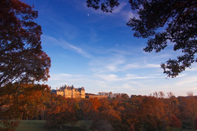
Biltmore Estate
-
This beautiful chateau, with gardens and grounds designed by Frederick Law Olmsted, has over 22 miles of pavement and singletrack trail lining the French Broad River and surrounding forests. Access to the Biltmore grounds requires a general admission ticket, which also includes admission into the Biltmore House and Gardens and the Antler Hill Village and Winery. See more about Admission here: https://www.biltmore.com/landing/ticket-options/
photo by Joanne O’Sullivan
-
Varying, up to 22 miles of pavement / trail
-

-
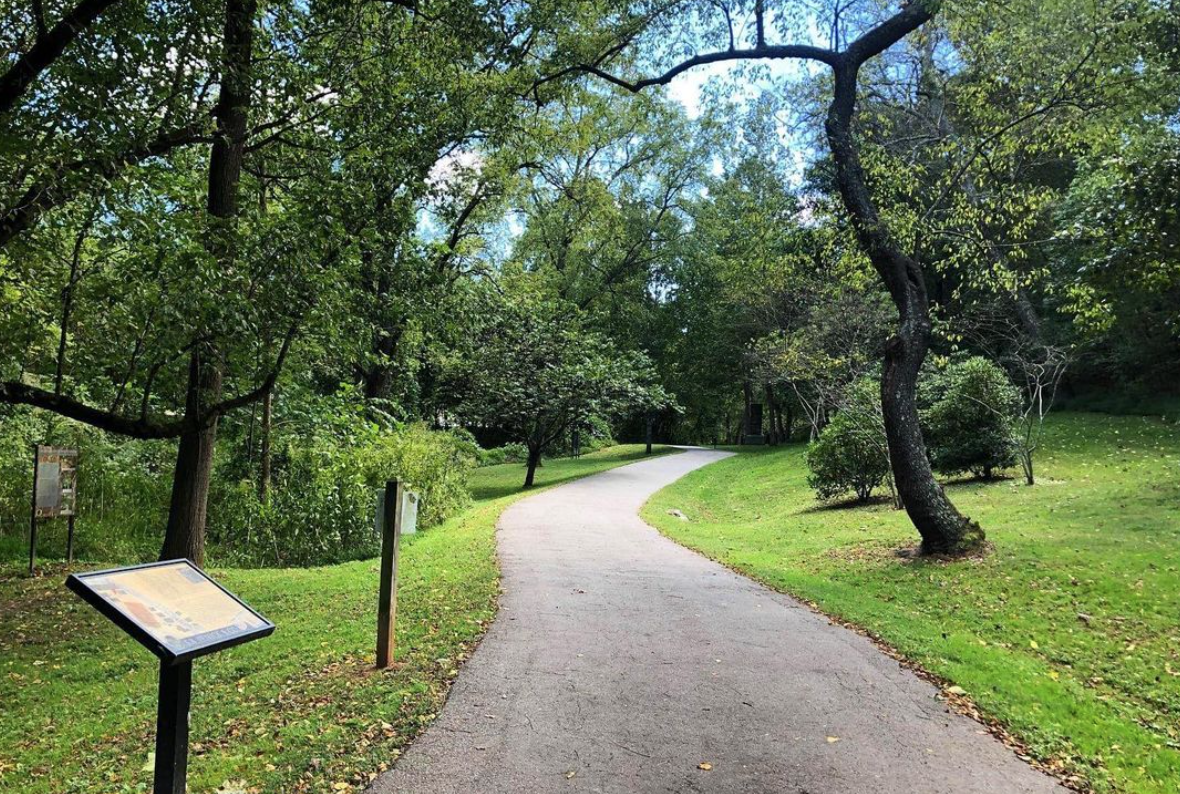
An urban oasis with a shady half-mile loop trail that highlights 600 species of plants native to the Southern Appalachians. Hop onto the nearby Reid Creek Greenway that connects at W T Weaver Blvd and Broadway if you want to extend your run with some pavement. Swing by Hi-Five coffee for a cup of coffee or a pastry while you’re in the area!
-
.5 mile loop
-
Trail
-
UNCA Botanical Garden
-
UNCA Botanical Gardens
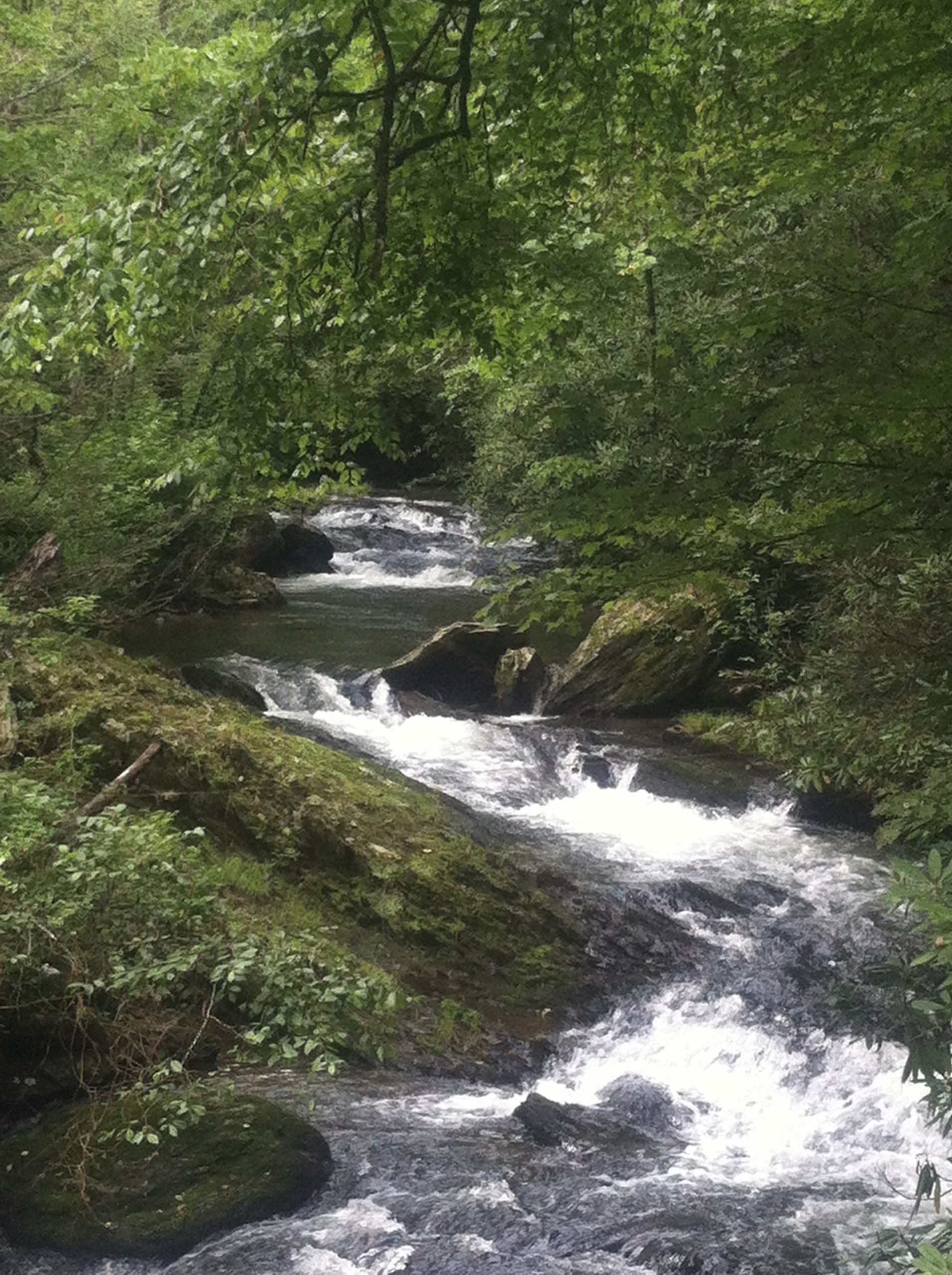
Sam’s Gap to Big Bald
-
Contributed by JR staff member Luke Paulson
This is an out-and-back route on the single track of the Appalachian Trail and is one of Luke top three running routes in the Asheville area. 6 miles “out” and 6 miles “back” for a total of just over 12 miles. Expect well-maintained and well-marked singletrack for the entirety of this route that climbs from 3,800’ above sea level to 5,500’ above sea level. While the trail is maintained throughout the route’s entirety, it does get much more technical as you get closer to Big Bald (turn around point) featuring lots of scattered rocks in the final mile. Expect lots of uphill on the way “out” and lots of downhill on the way “back”, though most of the elevation change is gradual to moderate (only a few steeper inclines). Expect stunning 360 degree mountain views at the turn around point (Big Bald summit).
Route Instructions: Plan to park in the roadside parking lot located at Sam’s Gap (located 30m south of I-26 overpass). Enter the singletrack trail through the wooden fence on the other side of the street directly across from the parking lot (Old Asheville Highway). Stay on the singletrack for the entirety of this route. You will emerge onto Big Bald shortly after 6 miles. This is your turnaround point. You will go back the same way that you came from. Look for white spray painted dashes on the trees – these are your trailblazes and indicate you are on the right trail.
Luke’s Tips: This route is at 3k-5.5k feet above sea level which means temperatures will be about 10 degrees F less than in Asheville. Don’t be surprised to find significant snowpack in the winter months. While there is often flowing water along the route (especially in the 2 miles before the turnaround), plan to be self-sufficient and pack all the water and nutrition that you may need. Be careful – this route is for runners familiar with technical terrain and will take 2-5 hours to complete. Enjoy.
photo by Rachel Veale
-
12.3 miles roundtrip
-
Singletrack on the Appalachian Trail
-
Sam’s Gap Trailhead
-


-
Contributed by JR staff member Jenni Austin
Downhill and rolling hills for the first 4 miles, then tough climbing back up the last two-ish miles to the Mt. Mitchell summit area. Great sunset views from Mt. Craig!
Park at the Mt. Mitchell summit parking lot. Head towards Mt. Mitchell summit, turn onto Old Mitchell Trail. Take a left onto Camp Alice Trail and then continue left on Commissary Trail. Continue on Buncombe Horse Range Trail, keep left on Buncombe Horse Trail when it splits with Mt. Mitchell Trail. Continue on Buncombe Horse Trail but keep an eye out for the Big Tom Gap Trail on the left. Head up Big Tom for some climbing to Deep Gap Trail. Left on Deep Gap Trail and continue towards Big Tom summit and Mt. Craig Summit. From Mt. Craig, continue on Deep Gap Trail until you arrive back at Mt. Mitchell summit parking lot.
-
5.86 miles
1,312’ elevation gain
-
100% singletrack
-
Mt Mitchell Summit parking lot
-
Up Big Tom Loop
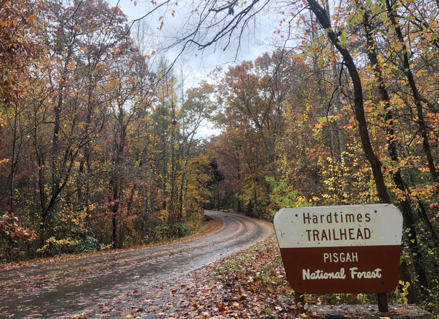
Greens Lick Grind
-
Contributed by Adam Lion
This loop is in the popular Bent Creek Experimental forest, just 15 minutes southwest of Asheville. Enjoy scenic views and extremely steep single track trail during this 8.2 mile loop, which climbs 1,400 ft into the mountains. This is a difficult run with a mixture of technical single-track, gravel forest-service roads, and a small amount of paved road running.
Park at the Hard Times parking lot in Bent Creek. Begin your run at Hard Times road, which is gated off to vehicles. Take a right at the T-Intersection onto Hard Times Spur. Continue onto Hard Times Road (FS481F). Pass the Wesley Branch Road intersection, and continue onto Campground Connector. At the intersection of Bent Creek Gap road, continue straight onto Boyd Branch Road. Immediately after you pass the gate, take a left onto Lower Sidehill Trail, which is single-track. After about 1 mile, take a right at the T-Intersection onto Laurel Branch Road. Stay on Laurel Branch Road for .5 miles, and then take a left onto the single-track of Greens Lick. Climb this steep trail for 2 miles, gaining 800 feet of vertical gain. At the top of Greens Lick, take a right onto the single track of N. Boundary Road. Descend on this trail for 1 mile, until arriving at the 5-points intersection. Here, take a soft right onto Ingles Field Gap trail. After descending for .5 miles, take a sharp right onto Ingles Field Gap Connector. At the T-Intersection, take a left onto Boyd Branch Road. After .75 miles, take a right onto Ledford Branch Road. Continue left onto the paved Wesley Branch road, which takes you back to the Hard Times Parking Lot.
-
8.2 miles
-
50% Single Track, 45% gravel road, 5% paved road
-
Hard Times Parking lot in the Bent Creek Experimental forest


-
This state forest is tucked away in the Little River Valley near Brevard, NC. About 30 min southwest of Asheville, DuPont is a local favorite weekend go-to. With 10,000 acres of hiking and biking trails, waterfalls, lakes, rocky ridges, and mountain summits, this State Forest is a must-see (there is a reason why we have hosted an annual 12K here for 20 years and counting!)
One route we recommend: 7.6 mile High Falls / Three Lakes Loop. It is mostly gravel with a few easy singletrack segments. Park at the Visitor Center (water and restrooms available here) and head South towards several of the lakes on the DuPont property. You’ll pass Lake Dense, Lake Julia, and Lake Alford before heading back north to where you started. This route includes Buck Forest Road, Pitch Pine Trail, and the Three Lakes Trail.
-
Varying distances
-
Trail
-
DuPont State Forest
Beaver Lake Loop
-
This jogging trail forms a part-asphalt, part-dirt loop around the man-made Beaver Lake and the surrounding neighborhood. Beautiful water and mountain views. And you can stop for a cup of coffee and a donut at Geraldine’s Bakery right down Merrimon road after!
-
1.9 mile loop
-
Mostly trail with a small stretch of sidewalk
-
Beaver Lake Bird Sanctuary

-
North Carolina’s state trail and longest marked footpath, the Mountains to Sea Trail (or the “MST” as we say around here) stretches almost 1,200 miles from the Great Smoky Mountains to the Outer Banks. In the Asheville area, the MST roughly parallels the Blue Ridge Parkway, and can be accessed at various points for a good out and back run – we recommend parking at the Folk Art Center, Rattlesnake Lodge Trail at the intersection of the Parkway and Ox Creek Road, or Craggy Gardens for exceptional mountain views. The entirety of the MST is marked by white blazes.
Fun Fact: One of the area’s most historic trail races, the Shut-In Ridge Trail Race hosted every November by Jus’ Running, is a 17.8-mile section of the MST that runs from the mouth of Bent Creek all the way to the Mount Pisgah parking area. With over 5,300 feet of elevation gain, this run is a significant challenge.
photo by Justin Costner
-
Out and back or point to point, varying distance
-
Singletrack
-
Mountains to Sea Trail
Snooks Nose Trail
-
A local must-see, and not for the faint of heart! Located at the southeast end of the Pisgah National Forest, this trail starts from the Curtis Creek Campground (about 30 miles east of Asheville). The trail follows an old logging road that ascends 1775 feet over 2 miles up to the Snooks Nose Lookout. Be prepared for incredible views, with the Linville Gorge to your east and the Blue Ridge and Black Mountains to your west. For even more views, continue out 2 more miles to the fire tower at Green Knob.
Photo by Lyle Mitchell
-
4-8 miles
-
Gravel road and singletrack
-

-
Park just past Curtis Creek Campground (You’ll pass a campground area / pit toilets on your right. Keep driving, and there will be a public parking area on your left hand side next to a trail sign). Head north on Curtis Creek Rd for ~3.5 miles, climbing over 2,000 ft until you hit the trail intersection for Lead Mine Gap trail. This turn can be hard to miss – keep your eyes peeled for a sharp turn up the mountain on your right side. Stay on Lead Mine Gap Trail for about 2.2 miles, climbing up and down some technical terrain (and most likely brushy vegetation if it’s summertime) until you hit the turn off for Hickory Branch trail on your right side. Take Hickory Branch for the final ~1.5 miles of this route, losing 1,100 ft of gain as you descend back into Curtis Creek Campground where you started! Author / JR Staff Rachel Veale highly recommends taking a celebratory dip in Curtis Creek.
-
7.15 miles
2,177 ft of gain
-
50% gravel, 50% singletrack
-
Curtis Creek Campground, 3799 State Rd 1227 Old Fort, NC 28762
-
Curtis Creek Climbs

-
Starting at the Asheville Botanical Gardens, turn right down WT Weaver Boulevard towards the intersection. Cross the intersection at Broadway Ave and continue left on the Reed Creek Greenway. Stay on the greenway heading north until it ends at Elizabeth St. Turn right at Elizabeth, running uphill and turn left on Cumberland Ave then take a quick right on Bearden Ave. Cross over Montford Ave continuing on Courtland Ave, then take a right on Pearson Dr. Stay on Pearson Dr for about 0.25 mi and take a left on Gay St (Happy Pride!). Turn right on Madison Lane, right on Gray St, then turn right and get back on Pearson Dr. Turn left on Birch St and run into the Riverside Cemetery. Unfortunately, the roads inside the cemetery are not marked or named, but the route is similar to the cemetery loop in the Thomas Wolfe 8K. Upon entering the cemetery, stay straight on Riverside Cemetery Dr., then turn right in front of the maintenance building, you should be going down hill. Stay left at each intersection. As you begin to come back uphill, take a sharp left. At the next intersection, stay right and keep right as you continue uphill. Eventually, you will make your back to the entrance of the cemetery. Continue on Birch St and turn left at Pearson Dr. Keep left on Pearson Dr until Tacoma St. Turn left on Tacoma St. Turn right on Tacoma Circle and stay on Tacoma Circle until you’re back at Tacoma St. Take Tacoma St back to Pearson Dr. Take a left at Pearson Dr. Stay on Pearson Dr until you reach Hibriten Dr. Hibriten Dr is a circle that loops back to Pearson Dr. Once you’ve completed the loop and are back on Pearson Dr., run up Pearson Dr and take a left on Santee St. Turn right on Montford Ave then left on Zillicoa St. Say hi to the ghost of Zelda Fitzgerald! Continue on Zillicoa St running down hill until you intersect Broadway Ave. Take a right on Broadway, staying on the sidewalk. Cross Broadway at the intersection and now you’re back!
-
6.3 miles
-
Road
-
UNCA Botanical Gardens
-